STONE MOUNTAIN

CHEROKEE TRIAL

THE GRIST MILL

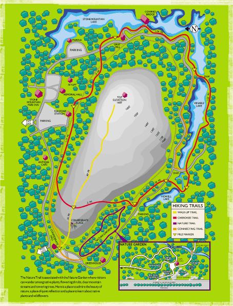
Hiking The Cherokee Trail
The Cherokee Trail is a 6 mile historic trail which explores much of the Natural District around the base of Stone Mountain.
The hike starts at Confederate Hall, near the west gate of the park.
(N 33° 48.648 W 084° 09.668)
1. Start the hike from Confederate Hall.
2. Hike to the top of the mountain using the walkup Trail.
3. Take time at the top to rest and view the countryside.
4. Return down the mountain by the same trail - WATCH FOR CROSS TRAIL MARKED BY WHITE BLAZES ON THE FLAT ROCK AND TREES - turn left at the cross trail. This is the beginning of Stone Mountain Cherokee Trail. It is approximately 500 yards up the mountain from the Flag Terrace.
5. Cross the R. R. tracks and walk approximately 100 feet – WATCH FOR DIRECTION CHANGE - trail turns sharply to the left.
6. Cross Robert E. Lee Blvd. in the marked crossing adjacent to the playground and walk into the woods.
7. Walk across the top of the dam and the spillway. Turn left 50 feet beyond the spillway.
8. Cross the second spillway using the bridge and then cross the dam - WATCH FOR THE TRAIL TURNING T0 THE RIGHT AT THE END OF THE DAM.
9. Follow the shoreline until reaching the Grist Mill. Walk the elevated plank way around the mill. At this point the trail follows the water flume to its beginning at a small mill pond, and then turns right and then left to arrive at Robert E. Lee Blvd. where there is a marked crossing.
Optional: If you would like to learn about the old Stone Mountain granite quarries, turn left on the sidewalk after crossing the street and proceed about 100 yards to the entrance of the “Raising A Ledge” exhibit. After viewing the exhibit, go back to the point at which you crossed Robert E. Lee Blvd. and turn left, continuing the hike.
10. After crossing Robert E. Lee Blvd., go into the woods following an old dirt road.
11. Cross the R.R. tracks and walk through the Nature Area at the base of the mountain.
12. The trail exits the woods and proceeds across the lawn on a sidewalk. Turn left and cross the track at the crossing before the R.R. Station and then turn right on the sidewalk.
13. As the walkway starts curving to the left, watch straight ahead for the white blazes going up the hill through the natural area. Pick up the trail as it goes through the picnic area behind the R. R. Station.
14. The trail continues about a mile along the northern side of the mountain before turning left at a tee in the trail, and then goes up across the open rock. It soon meets the walkup Trail. This is the end of Stone Mountain Cherokee Trail. Turn right and return down the mountain using the walkup Trail arriving at Confederate Hall.
Photos of GPS in Gallery
CHEROKEE TRAIL MAP