
The Third Corps of the Army of Northern Virginia was a military organization w/in the Confederate Army of Northern Virginia during much of the Civil War. The corps was formed in mid-1863 and served until Lee's surrender April 9, 1865, near the end of the war. The Third CS Corps was also known as Hill’s Corps. The unit was commanded by General James Longstreet (November 9, 1825 – April 2, 1865). Longstreet was a career U.S. Army officer in the Mexican–American War & Seminole Wars & a Confederate general in the American Civil War. He gained early fame as the commander of the "Light Division" in the Seven Days Battles & became one of Stonewall Jackson's ablest subordinates, distinguishing himself in the 1862 battles of Cedar Mountain, Second Bull Run, Antietam, & Fredericksburg.
Following Jackson's death in May 1863 at the Battle of Chancellorsville, Hill was promoted to lieutenant general & commanded the Third Corps of Robert E. Lee's Army of Northern Virginia, which he led at Gettysburg & the fall campaigns of 1863. His command of the corps in 1864–65 was interrupted on multiple occasions by illness, from which he did not return until just before the end of the war, when he was killed during the Union Army offensive at the Third Battle of Petersburg.
The Hill Corps monument is located on the right or west side of W. Confederate Ave if traveling south, just south of McMillan Woods. The monument faces the east. 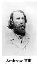 Parking is available at small, intermittent cutouts or small shoulders. Please do not park on the grass, park on the asphalt. I cannot emphasize that enough! You will be ticketed. I visited this monument on Saturday, March 10, 2012 at 12:51 PM, just before the clocks were set ahead for the Spring. I was at a 582 foot ASL elevation.
The monument was erected in 1907, according to the NPS/NRHP narrative. Another source has it at Dec. of 1906. It is simply amazing with all the work put into these monuments, not one person had the wherewithal or simple presence of mind to write down the dedication dates or manufacturing dates. I know for sure the work was done under the direction of the Gettysburg National Park Commission (established by the United States Dept. of War), after they took over the administration of the park from the Gettysburg Battlefield Memorial Association (whose funds had expired) on March 3, 1893, and whose stewardship was then transferred to the Nat'l Park Service in 1933, which entity still operates the park today). SOURCE
As already mentioned, there were three Confederate Corps that participated in the Battle of Gettysburg. The waymark for the Longstreet Corps Tablet can be found HERE. The waymark for the Ewell Corps Tablet can be found HERE.
Draw the Sword, with descriptive help from the NPS site, offers the following description: A rectangular granite monument, with a large bronze tablets thereon, describing the engagements and movements of each army corps. Rock-faced granite monolith, 4 feet 2 inches (close to it) wide by 2 feet wide (thick) by 7 feet high (this is my reckoning), with bronze narrative tablet mounted on obverse polished face. One of the Confederate army corps monuments, denoting the service of the First Corps, Army of Northern Virginia. Constructed by Albert Russell & Sons Co. of Newburyport, Mass. & erected by the U.S. War Dept. (well, not exactly accurate). The inscription on this tablet reads:
Army of Northern Virginia
Third Army Corps Lieutenant General Ambrose P. Hill
Anderson's Division Major General R.H. Anderson
Heth's Division Major General Henry Heth, Brigadier General J.J. Pettigrew
Pender's Division Major General William D. Pender, Brigadier General James H. Lane, Major General I.R. Trimble
Artillery Reserve, None Batteries, Colonel R. Lindsay Walker
July 1. The Corps was near Cashtown. Heth's Division at 5 a.m. moved towards Gettysburg. Two Brigades with Artillery advancing across Willoughby Run were soon engaged. Archer's Brigade was driven across the run. After resisting an hour Heth's Division formed in line west of Willoughby Run and advanced with Pender's Division in reserve 2.30 p.m. the right of Ewell's Corps appeared on the left. Pender's Division was ordered forward. After a severe contest the Union forces were driven back and through the town. The two divisions bivouacked on the ground gained. Anderson's Division bivouacked two miles in rear.
July 2 Anderson's Division extended to the right along the crest of hills facing Cemetery Ridge. Pender's Division occupying the crest from the Seminary and joining Anderson's Division with Heth's Division in reserve. The Artillery in position on Seminary Ridge. The First Corps ordered to attack the left of Union forces the Third Corps to co-operate. General Anderson moved forward three Brigades connecting with left of McLaws's Division and drove the Union forces from their position. Anderson's right becoming separated from McLaws's left and no support comming to these Brigades they retired to their former lines.
July 3. The Corps occupied the same position Reserve Batteries were placed facing the Union lines. The Confederate line held by Anderson's Division half of Pender's and half of Heth's the remainder of Corps ordered to report to General Longstreet as a support in the assault to be made on the Union position on Cemetery Ridge. About 1 p.m. the Artillery along the line opened fire 3 p.m. the assault was made and failed. Anderson's Division was held in reserve. The troops fell back to former position.
July 4. The Corps took up the line of march during the night.
Casualties killed 807, wounded 4407, missing 1491, total 6735.
There are hundreds of non-sculpted monumentation for the various Confederate States & Union units which fought at Gettysburg. There are about 10 different variations of tablets, markers & monoliths by my reckoning. Six designs represent brigade (2), division (2), corps (2), & army headquarters (2), each different in a subtle way so as to distinguish between armies. Battalion/battery/advance position markers & regimental monuments for U.S. Regulars & Confederate have their own distinct design (2), bringing the total to 10 designs at the battlefield. The bronze tablets were created by Albert Russell & Sons Co. of Newburyport, Mass. The granite bases which accompany the various tablets were created by the Van Amringe Company from Boston, Mass. The cast iron tablets were of course manufactured by the aforementioned Calvin Gilbert. The 1910 Gettysburg Commission report lists the awarded contracts to these companies (not Gilbert) for the tablets. All of these tablets were designed by architect Colonel Emmor Bradley Cope (July 23, 1834 - May 28, 1927). He designed pretty much every tablet for both the Union & Rebel armies, each one distinct, w/ several different varieties. He is buried in Evergreen Cemetery  in Gettysburg, as well he should be as this park and most of the things seen here today were designed by him and as such, are his legacy. These monuments were erected just after the turn of the century during the first & beginning of the second decade of the 20th century. Each one has since been preserved or restored at least twice since the turn of the 21st century. The plaques & tablets were erected by the Gettysburg Park Commission (established by the War Dept.). The Gettysburg Park Commission is also referred to as the Gettysburg National Military Park Commission or the Gettysburg National Park Commission, to clear up any confusions, especially my own.
On October 1, 1898, the Gettysburg National Park Commission in a letter to the Secretary of War set gave recommendations for continuing the task of organizing & progressing the work of the Gettysburg National Military Park. Every November they wrote their annual report which outlined the work of the GNPC for that year. The following is an excerpt from that report relevant to this waymark. The link at the end of the paragraph will take you to the entire report. The method of marking the positions of troops on this field, as approved by the War Department, is to place the principal tablet or monument of each command at the position occupied by the command in the main line of battle, and to mark the several important positions subsequently reached by each command in the course of the battle by subordinate and ancillary tablets, with appropriate brief inscriptions giving interesting details and occurrences and noting the day and hour as nearly as possible. SOURCE
Most of the Commission reports have been digitized and can be found HERE. The initial 1893 report up to & including 1921 can be found here. 1922 to 1926 are missing & have yet to be discovered. The years 1927 to 1933 were discovered in 1996 and are also included. To my knowledge this is the most comprehensive list of documents that illustrated the development and formation of the park.
About these monument types:
CORPS HEADQUARTERS MARKERS (FOR UNION & CONFEDERATE TABLETS)
Corps headquarters are similar to division headquarters, consisting of a large, rectangular stone. The difference are the brass tablets set into the stone, which instead of being rectangular like the division tablets, instead have a curved-and-scrolled top, much more ornate & distinctive. I also found the Union Corps tablets to be higher & thicker than their Rebel counterparts.
The union tablets are kind of neat, each individual one having a corps or service branch symbol like the diamond of the Third Corps, the Maltese Cross of the Fifth Corps or my personal favorite, the Trefoil for the Second Corps. There can also be found a full moon, a crescent moon, a cross, and a star.
The 3 Rebel monuments are not so bedazzled w/ symbols, rather, at the top they just have written on bronze tablet, Army of Northern Virginia. There are only 3 of the Rebel monoliths compared to 9 of the Union Corps headquarters markers. One of the 9 is for the entire Artillery Reserve so technically there are 8 Corps represented at Gettysburg or 9 depending on your counting.
At Gettysburg, to understand the order of battle & how men were arranged, simply understand the logic & system behind the monuments. Sometimes however, there are weird exceptions which break the pattern & are confusing, making no sense. When I visited the Peach Orchard (a battlefield found here) I found 3 monoliths fashioned in the distinctive Corps design but upon closer inspection I found them to be not for the Union Corps but for the 1st & 2nd Divisions of the 3rd Corps (as well as the one for the entire Artillery Reserve which I can excuse).
There are 4 of these tablets at the beginning of the orchard, all lined up in a neat row. The only reason I can think for them being constructed in the same way & manner as the Corps tablet was to provide uniformity. The 3rd Corps Division tablets are the Birney's Division - US Division Tablet, 1st Division, the Humphreys' US Division Tablet, 2nd Division, the Randolph’s Artillery Reserve - US Division Tablet and the only authentic one, the Army of Potomac. Click the hot links provided to review those waymarks so as to have a clearer understanding. SOURCE & SOURCE
The Hill Corps Tablet is a contributing feature to the Gettysburg Nat'l Military Park H.D. which is nationally significant under NR Criteria A, B, C & D. Areas of Significance: Military, Politics/Gov't, Landscape Architecture, Conservation, Archeology-Historic. Period of Significance: 1863-1938. The monument is designated as structure no. M462.
From the Nomination Form:
Civil War tablet that marks position of Squires' Battery on July 3-4, 1863. Narrates events associated w/ Battery during Battle.
Short Physical Description:
Rough-hewn monolith, 4'2"x2', 7' high. Bronze inscription tablet, 3'7"x4'1", mounted on polished S face of monolith.
Long Physical Description:
Located on W side of West Confederate Ave, near North Carolina Memorial, south of McMillan Woods.
My Source
1. NRHP Nomination Form