
Ferncliff Trailhead - Ohiopyle State Park - Ohiopyle, Pennsylvania
N 39° 52.325 W 079° 29.634
17S E 628801 N 4414645
The Ferncliff Trailhead of Ohiopyle State Park is located on Ferncliff Avenue (Off Main Street/State Route 381) in Ohiopyle Borough, Fayettte County, Pennsylvania.
Waymark Code: WMFPRW
Location: Pennsylvania, United States
Date Posted: 11/14/2012
Views: 5
Ferncliff Trailhead - Ohiopyle State Park - Ohiopyle, Pennsylvania
This trailhead not only provides access to the Ferncliff Peninsula Natural Area, but also provides access to the Great Allegheny Passage as well as provides secure parking (By Reservation ONLY at the Park Office) for twelve vehicles for the passage and the nearby Laurel Highlands Hiking Trail
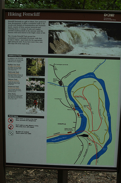
The Four Mile Ferncliff Peninsula Trail System includes:
All Trails are BLACK BLAZED
Ferncliff Trail:
1.7 miles, easiest hiking
All other Ferncliff Peninsula trails branch off of this loop trail which circles the peninsula. The trailhead is near the Ferncliff Parking Lot.
Buffalo Nut Trail:
0.1 mile, easiest hiking
This short trail is the first branch off of Ferncliff Trail and is a shortcut to Oakwoods Trail.
Fernwood Trail:
0.5 mile, easiest hiking
This trail features beautiful ferns and the remnants of the old Ferncliff Hotel.
Oakwoods Trail:
0.5 mile, easiest hiking
This trail passes through a mature hardwood forest.
Coordinates lead to the Parking Lot for ALL users
Trailhead/trail website: [Web Link]

Trail allowances or restrictions:
Hiking ONLY on Ferncliff Trail System to protect area to natural state.
Bikes allowed on GREAT ALLEGHENY PASSAGE, which you will cross to access the Ferncliff System.
Trail type: Dirt on whole system
Parking: Not Listed
|
Visit Instructions:
To claim a log for this waymark, some proof of a visit is required. This proof could be a simple photo of their GPS at the trailhead, a photo of the person at the trailhead, or a photo of a signature item that a person uses for photographs, at the trailhead.
In order to help other waymarkers who are looking for a nice hike/walk outdoors, you are encouraged to provide good feedback about the quality of the hike/trail.
Recent Visits/Logs:
| There are no logs for this waymark yet. |
|
|
|