[Ed Note: This WM edited to include all the text for visitors use. Original submission below marker text]
Marker Text:
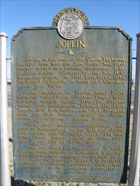
JOPLIN
Joplin, at the edge of the Ozark Highland, the city that lead and zinc built, was first sparsely settled as a farming community, 1838, by John C. Cox, followed by the Rev. H.G. Joplin, and othes. The first post office, 1840, was named Blytheville in honor of a Cherokee Indian, Billy Blythe.
Lead, discovered by Neosho miner David Campbell while visiting William Tingle, 1849, attracted settlers mainly from the Ozarks, though real development followed the Civil War. In 1870 E.R. Moffet and J.B. Sergeant sank the first bonanza shaft on Joplin Creek, precipitating a mining boom.
Soon rival interests established the town of Murphysburg on the west and Joplin City on the east of Joplin Creek. The two towns were joined briefly as Union City, then as the City of Joplin, 1873.
Zinc ore (blackjack), discarded at first, became more valuable to mine than lead. By 1890 Joplin held national recognition as a lead and zinc producer. Capt. E.O. Bartlett's process for making sublimed white lead contributed to the expanding prosperity.
Joplin is in a resort area of spring-fed steams, rugged mountains, and deep valleys named for its beauty and popularity the Ozark Playgrounds of Missouri. The city lies in both Jasper and Newton counties.
Often called the "Capital of the Empire District," Joplin is an industrial, commercial, transportation, and distributing center for parts of 4 states. Among many factors making Joplin an industrial and wholesale point are "Smelter Hill," where much Tr-State ore is converted into commercial products; vast truck-in stockyards; and distributing center for electric power.
Nearby Webb City, also founded on lead and zinc, turned to diversified industry at the end of the first World War. Centerville, another boom town, declined after that war. In the area is abandoned Oronogo Circle Mine, said to have had an output valued at 30 million dollars.
Outstanding Tr-State Mineral Museum is in Shifferdecker park. In Joplin was home of John M. Malang noted leader in Missouri's highway development.
Marker Erected by: State Historical Society of Missouri and State Highway Commission.
Date Marker Erected: 1953.
County of Marker: Jasper.
Location of Marker: Historic Rt.66, 7th Street.
Marker Text:
As always have fun be safe and
HAPPY............................................WAYMARKING