|
 Giant Sequoia National Monument, California - Northern Part
N 36° 45.649 W 119° 06.628
11S E 311620 N 4070416
Protecting the world's largest trees
Waymark Code: WM4ET5
Location: California, United States
Date Posted: 08/13/2008
Views: 104

|
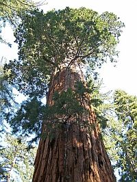
Giant Sequoias, the world's largest trees.
|
 |
|
The US Forest Service has identified 51 individual sequoia groves, 21 of them are located in Sequoia National Park and four more are in Kings Canyon National Park.
Giant Sequoia National Monument now connects the two parts of Kings Canyon NP and also extends federal protection of sequoia groves beyond the boundaries of the two national parks, adding 10 more groves to what is now the largest consecutive area of protected sequoia forests. Amongst others, the area is home to Stagg Tree, the world's fifth largest tree.
Although now called a National Monument, it is still a wilderness area under the jurisdiction of the US Forest Service.
|
|
But there is a lot more to see besides giant trees! We have waymarked a beautiful lake, an increadible hike down to the junction of two forks of the Kings River, a number of really cool waterfalls and an interesting cave, all within the boundaries of this protected area. Just click on the images to get to those waymarks.
|
We hope that these pictures taken during our last visit will spark your interest.
Estimated size of the public land (in regional measurement standard: hectares, acres, kms, etc.): 327,769 acres

Is there a trail system?: Yes
If there is a trail system, please describe length, terrain, etc.:
extensive
What points of interest are there?:
lakes, waterfalls, 10 individual sequoia groves
What activities are available?:
hiking, fishing, cross country skiing
List of known hazards (cliffs, snakes, poison plants, etc.):
bears, cougars
Dogs Allowed?: No
Is a permit/fee required?: No
If a permit/fee is required please describe in detail how to get one, how much, etc.:
No entrance fee required, but in order to get to some of the areas, you will have to drive through Kings Canyon National Park, which charges a $10 fee.
Please supply the website of the land if available: [Web Link]
Hours of accessibility?: Not listed
|
Visit Instructions:
Visitors are encouraged to supply a picture of either themselves or their GPS at the trailhead and/or signage of the public access lands - describe your experience there and what you saw - tell us why other folks should come visit!
|