
Lava Island Falls, Oregon
Posted by:  Volcanoguy
N 43° 59.212 W 121° 23.824
10T E 628542 N 4871663
A series of small falls and rapids on the Deschutes River that collectively are known as Lava Island Falls.
Waymark Code: WM4TX
Location: Oregon, United States
Date Posted: 12/11/2005
Views: 32
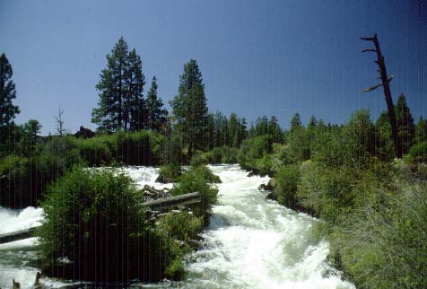
Lava Island Falls on the Deschutes River consists of a series of small falls and rapids where the river drops 40 feet over a distance of a quarter mile. The river splits into two channels. The main channel crosses the lava flow and flow along the east side of Lava Island. The other channel is much smaller and follows the west side of Lava Island. There is no viewpoint from which the falls can be viewed. To obtain a view a person must cross over onto Lava Island and the walk across the lavas and find a spot with a view. For more information on Lava Island Falls check the Waterfalls of the Pacific Northwest Website.
Please post a photo at Lava Island Falls when you log this waymark.
Geologic History of Lava Island Falls
As Newberry Volcano has grown over the last half million years it has gradually been displacing the Deschutes River westward. Over the last 100,000 years, two eruptions have shaped the Lava Island Falls area. Prior to 80,000 years ago, the Deschutes River was located somewhere to the east. About 80,000 years ago an eruption on the northwest flank of Newberry produce a large tube-fed basalt flow that moved north and west. Much of the flow passed through Lava River Cave and another branch went north to underlie Bend and extend almost to Redmond. This large flow destroyed the previous river channel and over time a new channel was established along the western edge of the flow. Over the next 70,000 years the river deepened new channel.
Prior to the eruption of Lava Butte (7000 years ago), the Deschutes River occupied a canyon (80 to 100 feet deep) from Bend to a point several miles upstream from Benham Falls. The eruption of Lava Butte again blocked the Deschutes River. The lava flows not only filled the deep canyon of the Deschutes from the Benham Falls area to Dillon Falls area, it also filled another segment upstream from Lava Island Falls. Blockage of this segment of the canyon forced the river to follow the edge of the Lava Butte until it reaches Lava Island Falls where the main channel of the river crosses the lava flow and cascades down into the original river channel. Map of Lava Butte Flows and Deschutes River