|
 Concentric Pentagons - San Jose, CA Posted by:  DougK DougK
N 37° 12.248 W 121° 50.988
10S E 602067 N 4118137
A set of concentric pentagons, drawn while riding my bicycle around a 2.5 mile circuit.
Waymark Code: WM6GVT
Location: California, United States
Date Posted: 06/02/2009
Views: 69
Click on any picture to see larger images.
Click the blue links for more information and other waymarks.
|
Ever since the first GPS tracklog art "1" was posted (how appropriate for the first submission),
I've been looking at maps trying to find a nice map subject to track.
Blocks? Squares? Naw, too common, too easy.
Finally, I realized there was some potential in my own neighborhood!
There are a set of streets laid out as three concentric Pentagons.
Nevermind that the street names are all Something Circle,
the streets are shaped like pentagons, with a connecting cross street.
Since the total length of all the streets approaches 2.5 miles, I decided to ride this on my bike.
I got to the location, took some picture of the three street names and the cross over street.
|
Mountain Quail Circle
The Inner Pentagon
|
Quail Creek Circle
The Middle Pentagon
|
Valley Quail Circle
The Outer Pentagon
|
|
I initialized track recording on two other GPS devices to get clear track recordings. And set off to ride...
When I completed the trip, I took some quick picture of my bicycle recording devices.
|
|
When I got home, I downloaded the track data into Garmin Roadtrip for Macintosh.
Roadtrip plots the points against a mapless background (since I don't have any Garmin map products loaded).
|
|
On the left is the track representation as shown in Garmin Roadtrip,
while on the right is a terrain map showing the same roads in about the same orientation and size.
|
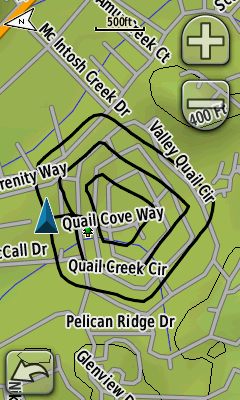
Garmin Oregon Screen Shot
One of the great features of the Garmin Oregon GPS unit is the ability to take an actual screen shot picture of the display.
It eliminates the glare and reflection on the screen, as well as the hand in the picture.
The drawback is that the track data is always displayed above the onscreen map.
|
|
Track Length: 2.5

Track Length Units: Miles
Uploaded Track: [Web Link]
|
Visit Instructions:
You must visit the given co-ordinates and provide a photo. Beyond that, there are no mandatory additional visit requirements, but you may want to try your hand at reproducing the design in the original Waymark. Go on ... why not? However, you can't log your copy of the original track as a new waymark ... for that you'd need to do it in a new location.
Recent Visits/Logs:
| There are no logs for this waymark yet. |
|
|
|
|