
Samuel de Champlain - 1609 - Ticonderoga, NY
Posted by:  Telomere
N 43° 50.520 W 073° 23.019
18T E 629933 N 4855594
A small marker, of the older type, describing an interesting skirmish.
Waymark Code: WM6QMZ
Location: New York, United States
Date Posted: 07/09/2009
Views: 7
NEAR HERE ON JULY 30, 1609
SAMUEL DE CHAMPLAIN
AIDED BY TWO FRENCHMEN AND
HURON AND MONTAGNAIS
ALLIES DEFEATED A BAND OF
IROQUOIS WARRIORS.
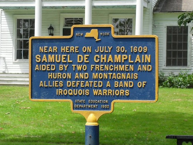
Although historians do not know the actual location of the events, the marker can be found on the front lawn of the Pell estate house, on the grounds of the Fort Ticonderoga historic preserve. The Montagnais were Canadian tribesmen who had a long-standing conflict with the Iroquois. Historic information indicates the battle was primarily between the tribes, and Champlain and his men were assisting - and during the battle shot 2 Iroquois chieftains. Read more - click on the wikipedia link below.
Marker Name: Samuel de Champlain 1609

Marker Type: Other (Explain)
Agency: NY State Education Dept.
Dedication Date: -9223372036854775808
City/Town/Village Name: Ticonderoga, NY
County: Essex
Region: The Adirondacks (Region 5)
Website: [Web Link]
|
Visit Instructions:
As a suggestion for your visit log, please make every effort to supply a brief-to-detailed note about your experience at the waymark. If possible also include an image that was taken when you visited the waymark. Images can be of yourself, a personal waymarking signature item or just one of general interest that would be of value to others. Sharing your experience helps promote waymarking and provides a dynamic history of your adventures.
Recent Visits/Logs:
| There are no logs for this waymark yet. |
|
|
|