|
 Cranberry Glades Botanical Area - Monongahela National Forest - Hillsboro, West Virginia
N 38° 11.872 W 080° 16.511
17S E 563466 N 4228017
The largest bog of West Virginia is located within Monongahela National Forest off of State Route 39/55 in Pocahontas County, West Virginia.
Waymark Code: WMER6N
Location: West Virginia, United States
Date Posted: 06/30/2012
Views: 5
Cranberry Glades Botanical Area - Monongahela National Forest - Hillsboro, West Virginia
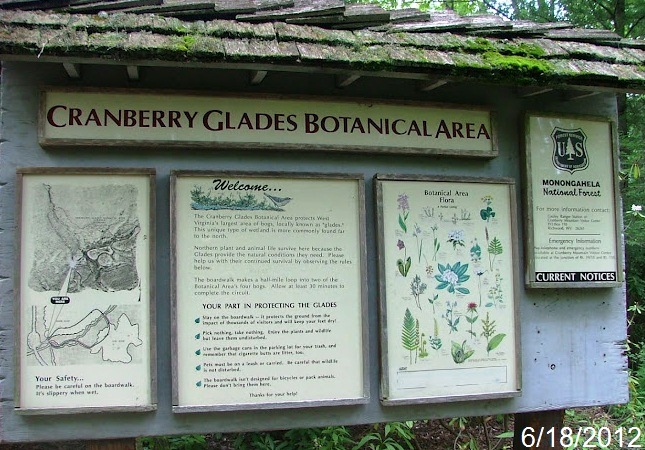
The Cranberry Glades Botanical Area protects the largest area of bogs in West Virginia. Bogs are acidic wetlands more commonly found in the northern areas of this country and in Canada. The ground in a bog is spongy and consists largely of partially-decayed plant material known as peat. Because of its unique conditions, some unusual plants grow in bogs, including carnivorous or insect-eating plants. The Botanical Area encompasses 750 acres.
The Cranberry Glades consists of four bogs whose plant and animal life is similar to that found in the bogs or "muskegs" of the north. This life spread southward with the changing climatic conditions that allowed glaciers to creep across the northern part of our continent. Several species ended their migration here, and the Cranberry Glades are now the southern-most point in North America where some of these life forms are found.
Estimated size of the public land (in regional measurement standard: hectares, acres, kms, etc.): 750 Acres

Is there a trail system?: Yes
If there is a trail system, please describe length, terrain, etc.:
Universally-Accessible Boardwalk serves two of the four bogs
What points of interest are there?:
Cranberry Glades Bogs
What activities are available?:
Nature Viewing
Hours of accessibility?: Sunrise-Sunset (May - October)
List of known hazards (cliffs, snakes, poison plants, etc.):
Wet Walking
Dogs Allowed?: No
Is a permit/fee required?: No
Please supply the website of the land if available: [Web Link]
If a permit/fee is required please describe in detail how to get one, how much, etc.: Not listed
|
Visit Instructions:
Visitors are encouraged to supply a picture of either themselves or their GPS at the trailhead and/or signage of the public access lands - describe your experience there and what you saw - tell us why other folks should come visit!
Recent Visits/Logs:
| There are no logs for this waymark yet. |
|
|
|
|