This historical 'T' marker is part of a series of historical markers located in parts of Nevada, California and Oregon and placed by the local Trails West organization of volunteers to mark important parts of emigrant trails that were traveled in the mid-1800s in this part of the country.
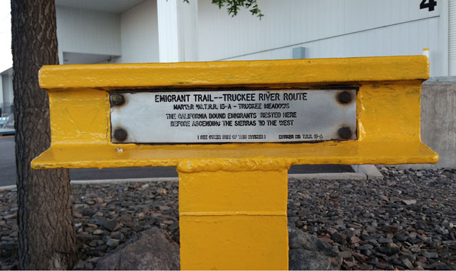
Tucked away under some trees next to the Reno Convention Center, this marker notes the Emigrant Trail which passed through this location. The marker has two sides of text. The front side reads:
EMIGRANT TRAIL--TRUCKEE RIVER ROUTE
MARKER NO.T.R.R. 13-A -- TRUCKEE MEADOWS
THE CALIFORNIA BOUND EMIGRANTS RESTED HERE
BEFORE ASCENDING THE SIERRAS TO THE WEST(SEE OTHER SIDE OF THIS MARKER) MARKER NO. T.R.R. 13-A
The back of the marker reads:
THIS MARKER IS NO 13-A OF A TOTAL OF 70 PLACED ALONG
THE HUMBOLT, CARSON, AND TRUCKEE RIVER ROUTES. FROM THE
APPLEGATE-LASSEN-NOBLES TRAIL JUNCTION NEAR IMLAY TO
THE SIERRA NEVADA SUMMITS.(SEE OTHER SIDE OF THIS MARKER) MARKER NO.T.R.R. 13-A
There is a very nice web site by the Oregon-California Trails Association dedicated to all the emigrant trails that led west and includes an interactive map that visitors can click onto to highlight different emigrant trails that led west. The Trails West Inc. website contains a page devoted to the Truckee Trail.
Sometimes history needs to be rewritten when there is evidence to contradict prior, 'understood' knowledge of supposed historical 'facts'. Such is the case with this particular T-marker noting the emigration through this area.
I discovered an online article written by Don Wiggins on the Trails West Inc. website that highlights the Truckee Trail that passed through Truckee Meadows as being made up of multiple trails, rather than a single trail for all emigrants (which was an understood assumption when this T-marker was erected here). Wiggins, a docent of the Nevada Historical Society in Reno, notes that depending on seasonal conditions and emigrant ingenuity, the Truckee Trail had as many as five different trail routes through Truckee Meadows, depending on the year. Wiggin's claim is based off of numerous emigrant diaries he read that give evidence to support this claim. The article reads (important info pertaining to this marker in bold):
The Route Through Truckee Meadows
Extensive research over the past decade by Don Wiggins, a docent at the Nevada Historical Society in Reno, Nevada, has revealed a far more complex development of emigrant wagon trails into and across Truckee Meadows in the 1840's and 50's than emigrant trail historians have heretofore realized. His research also has generated a heated reaction by local Reno trail buffs who found a forum for their views in two articles in the Reno Gazette-Journal, one in 1996 and the other in 2000. Wiggins has relied heavily on emigrant diary evidence in verifying the location of the various routes comprising the Truckee Trail in the Reno-Sparks area. This is in accordance with accepted emigrant trail research methods. Among trail researchers, it's axiomatic that the closer in time the evidence is in relation to the trail under investigation, the more reliable that evidence becomes. Emigrant diaries are written eyewitness accounts and as such are the most reliable evidence available. Of course, some diary descriptions are very difficult to decipher. However, trail researchers try to get into the mind of the diarist to see the world as he or she perceived it. This is no easy task and can be fraught with interpretive difficulties. Nonetheless, using established research procedures, Don Wiggins has been able to reconstruct with remarkable accuracy the varied and complex nature of the routes emigrants took to reach the Truckee Meadows between 1846 and 1854.
Prior to Don Wiggin's research and reconstruction of these emigrant trails, the trail interpretation of Walter W. Mulcahy, of Sparks, Nevada, had defined the emigrant trail routes in the Reno-Sparks area. In two newspaper articles for the Nevada State Journal on March 25 and April 1, 1962, Walt Mulcahy described the original emigrant trail as a single, fixed route that remained unchanged throughout the emigrant period of the 1840s and 50s. He believed the trail went all the way through the Truckee River Canyon, coming out at its mouth on the south side of the river near the present water treatment facility. Immediately after leaving the canyon, according to Mulcahy, emigrants confronted impenetrable sloughs (associated with present Steamboat Creek) which forced them to travel south about 4-1/2 miles, through present Hidden Valley, over a pass or ridge, to a point where they could cross Steamboat Creek. From this crossing, emigrants with their wagons turned west along the north side of Huffaker Hills to some springs and meadows where emigrants camped, after which they continued northwest from the base of Rattlesnake Mountain, by the present Reno-Sparks Convention Center, to the Truckee River near the later Mayberry Crossing. Mulcahy found impressive trail ruts running south of Hidden Valley and equally impressive wagon artifacts and springs at the base of Huffaker Hills/Rattlesnake Mountain that were obliterated by housing developments. Knowing the later Henness Pass Toll Road to Virginia City of the early 1860's followed this route alignment, Mulcahy assumed this later freighting road was laid over the earlier emigrant trail.
Mulcahy held that the reason for the long swing to the south and then northwest was due to the extensive sloughs that existed north and south of the Truckee River just west of Steamboat Creek. This same explanation was repeated in the Nevada Emigrant Trail Marking Committee's Guide to their 70 markers, The Overland Emigrant Trail to California, first published in 1975 and reprinted several times. Walt Mulcahy was the principal author of the Guide. Based on Mulcahy's research and trail interpretation, three of the Nevada Emigrant Trail Marking Committee's steel rail makers were placed along this southern leg of his "Truckee River Route" (NETMC markers TRR-12, 13, & 13A).
Reno historian Harold Curran, in his Fearful Crossing published in 1982, accepted the Mulcahy southern route hypothesis with one modification. Having read more diary accounts, Curran realized emigrants had crossed the sloughs shortly after entering the valley at the mouth of the Truckee River Canyon. But, according to Curran, emigrants found this slough crossing so difficult that the majority continued south through Hidden Valley on the proposed Mulcahy southern route.
A number of conclusions can be drawn from the evidence that Don Wiggins has brought to light over the past decade of research and field verification:
1) The relationship of the sloughs and meadows in the Reno-Sparks area were the opposite of what Walt Mulcahy had presumed. Where Mulcahy had the impenetrable sloughs located, Wiggins found this area to be the famous Truckee Meadows where emigrants camped (not at the base of the Huffaker Hills/Rattlesnake Mountain as Mulcahy contended).
2) No documentary evidence uncovered thus far indicates the Donner party or any emigrants through 1854 camped in the vicinity of the springs on the old Short Ranch as the Nevada State Historic Marker No. 253 and NETMC marker TRR-13 state.
3) It is very unlikely that the old wagon artifacts that Mulcahy discovered at the springs on the north side of Rattlesnake Mountain were from emigrant wagons passing by this location in 1852 (since there is no documentary evidence they camped in this vicinity). More than likely these wagon parts derive from early settlers along Huffaker Hills in the late 1850's or freighting activity on the Virginia City and Henness Pass Toll Roads of the early 1860s.
4) Those impressive wagon ruts south of Hidden Valley that Walt Mulcahy found four decades ago (located by NETMC marker TRR-12) could not have been the result of emigrant travel between 1846 and 1854.
5) In 1849 emigrants could not take their wagons all the way through the Truckee River Canyon and come out onto the Truckee Meadows by way of the present water treatment facility at the mouth of the Truckee Canyon. However, prior to 1852, pack trains were able to squeeze through this narrow horse path.
6) After making their last crossing of the Truckee River in the canyon, (one mile west of present Lockwood), 49er emigrants continued one mile more and turned south up a steep hill in the Virginia Range to avoid the difficult passage through the mouth of the canyon. After crossing these hills, they descended into the northern end of present Hidden Valley (in the vicinity of Trails West marker T-18 at the end of Man of War Drive). Even today, all of this 2-1/2 mile segment of wagon trail, first located by Wiggins, can be followed from the Truckee River Canyon south into the north end of Hidden Valley.
7) After reaching the north end of Hidden Valley, emigrants crossed Steamboat Creek/Slough about directly west of their entrance into the valley. After crossing the slough, they turned into the lush meadows to camp and recruit their stock. This westerly route across the meadows was the main Truckee Trail from 1846 through 1850.
8) None of the diary evidence from 1846 to 1850 cited by Wiggins' critics in support of the southern route that Mulchay proposed (diary accounts of Clyman, Bryant, Perkins, & Loveland) describe emigrants taking a wagon trail through Hidden Valley which is an integral part of the Mulcahy southern route. The first diary reference to emigrants taking a wagon road through Hidden Valley was in 1863, but they were traveling to Virginia City not across the Truckee Meadows.
10) In 1853 and 1854 emigrants were still taking much the same routes out of the Truckee Canyon into the meadows as they had in 1852. The slough crossing (just south of the water treatment plant) was still very difficult due to the steep banks (as the Harriet Ward diary attests). And one emigrant in 1854, who left an account, tried to make it south around Steamboat Creek/Slough much as others had in 1852. He finally had to turn around after his party could no longer follow the faint trail along the slough. Thus by 1854, this longer circuitous route to reach the meadows was no longer being used for wagon travel.
11)The new diary evidence uncovered by Don Wiggins points to as many as five different wagon routes taken by emigrants between 1846 and 1854 from the Truckee River Canyon to the Truckee Meadows. Thus, emigrant wagon routes changed from year to year, and even within a migration year, due to water conditions and emigrant ingenuity. The five routes include: (1) The route out of the canyon at present Lockwood into the meadows in 1846 (described by Heinrich Lienhard). (2) The wagon route emigrants took in 1849-50. (3 & 4) The two routes taken by the Beckwourth Trail travelers beginning in 1852 which were different from those taken in 1849-50. (5) Finally, by 1854, though the diary accounts are difficult to interpret, a wagon trail entered the meadows on the north side of the river.
The new documentary evidence summarized above requires that we reconsider the old paradigm of a single, unchanging trail into and across the Truckee Meadows. We must shift our thinking to a new one that conforms to the new evidence and shows the changing trail routes from 1844 to 1854. This is how history works - by a continuous processing of new evidence that leads to new explanations and interpretations. Walt Mulcahy, and later Harold Curran, uncovered new evidence, worked hard to fit it into a plausible explanation, and increased our knowledge of trail routes. Decades later, research based on many new emigrant diaries and local records along with painstaking field work by Don Wiggins has greatly expanded our knowledge of the Truckee Trail in western Nevada and eastern California. Fortunately, the same research process over the past two decades has led to greater accuracy in mapping trail segments along the Oregon and California Trails. In short, our historical knowledge of emigrant trails is not frozen in time but expands and grows as we uncover new evidence.