Located just off Hwy 299 in a gravel parking area next to the Pit River is a historical 'T' marker that is part of a series of historical markers located in parts of Nevada, California and Oregon and placed by the Trails West organization of volunteers to mark important parts of emigrant trails that were traveled in the mid-1800s in this part of the country.
This particular T-marker marks the location of the historic California Lassen Trail that separated from the Applegate Trail and continued south to connect with the Nobles Trail that led southwest to the Sacramento Valley.
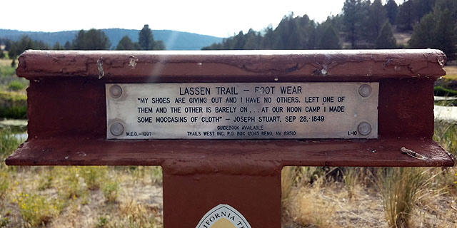
The marker text reads:
LASSEN TRAIL - FOOT WEAR
"MY SHOES ARE GIVING OUT AND I HAVE NO OTHERS. LEFT ONE OF
THEM AND THE OTHER IS BARELY ON...AT OUR NOON CAMP I MADE
SOME MOCCASINS OF CLOTH" - JOSEPH STUART, SEP. 28, 1849
GUIDEBOOK AVAILABLE
M.E.O. - 1997 TRAILS WEST INC. P.O. BOX 12045 RENO, NV 89510 L-10
The 'L-10' on the marker denotes this marker as the tenth marker of many markers to be found along the Lassen Trail. There is a very nice web site by the Oregon-California Trails Association dedicated to all the emigrant trails that led west and includes an interactive map that visitors can click onto to highlight different emigrant trails that led west. There is a nice writeup on the California Lassen Trail that reads:
One of the major trails to California, the Lassen Trail, was opened by Peter Lassen in 1848. Born in 1800 near Copenhagen, Denmark, Lassen immigrated to Boston in 1830 and in 1840 found himself at Sutter’s Fort in the Sacramento area. Obtaining 22,000 acres through a Spanish land grant, Lassen developed a self-sufficient community he called Bosquejo Rancho. He raised cattle and cultivated wheat, cotton and oats as well as planting a vineyard. Today, part of the New Clairvaux Winery in Vina is located on Lassen’s original ranch.
In the summer of 1848 Peter Lassen led the first party of wagons over his "short cut" to the goldfields of California. Probably hearing of the discovery of gold in California, the party of ten eager California-bound wagons from Missouri turned onto the new Applegate road heading toward southern Oregon, leaving the established, well-traveled California Trail in western Nevada. When they reached the south end of Goose Lake, Lassen turned his party southward past the east side of Lassen Peak and then turned west through Big Meadows to Deer Creek Meadows, heading for the Sacramento Valley and his ranch. After months of trails blazing, the exhausted group, supplies depleted, was ultimately rescued when a wagon party from Oregon headed to the goldfields came upon them.
During the migration season of 1849 anxious gold-seekers, worried over rumors of used-up grazing and poor water supplies along the Truckee River and Carson Rive Routes, eagerly took the new found trail. It was during this time that Lassen’s trail developed an undeserved bad reputation among the emigrants. While the gold-seeking ‘49ers who came through early in the year in pack trains found adequate supplies of grass and water, the later wagon trains found very little. The faster moving pack trains had quickly used up most of the grass and water resources along the trail, leaving the slow moving tail-end of the migration, populated with large numbers of families in wagons, to suffer from the lack of grazing and water. It was these wagon parties that maligned the trail, some even calling it the “Death Route.” Although reputed to be faster, the route proved to be longer than either the Carson or Truckee routes of the California Trail, sometimes taking as much as 30 days more.
By August 1849 all the California routes had been decimated by overuse and the military governor of California was receiving frightening reports of thousands stranded and dying along the Carson and Truckee Trails. Responding to the emergency, the governor ordered a $100,000 relief effort to be mobilized. Private citizens supplemented the fund with thousands of dollars of their own money. Relief parties were formed and sent out to meet emigrants on the Truckee and Carson Routes by late August. The commander of the relief effort, Major Daniel H. Rucker, soon learned that an even greater crisis was occurring on the Lassen Trail and diverted help there. Finally, at the end of November, the last stragglers along the Lassen Trail were brought into Lassen’s ranch. Major Rucker reported to the governor:
"A more pitiable sight I had never before beheld. There were cripples from scurvy, and other diseases; women, prostrated by weakness, and children, who could not move a limb. In advance of the wagons were men mounted on mules, who had to be lifted on or off their animals, so entirely disabled had they become from the effect of scurvy."
An emigrant quote of the time gives us a glimpse of the hardships recorded from their point of view:
"Oct. 7. There are several hundreds of people in this vicinity, and many of them are down with sickness. The prevailing diseases are fever, and scurvy. The latter is caused by living on salt provisions without vegetables. Living, as our company has done, mainly on fresh beef for meat, no symptoms of scurvy have thus far made their appearance among the members."
Amos Batchelder, 1849
Reports of these incidents brought a dramatic drop in the number of emigrants taking the Applegate-Lassen Trail in 1850. Many who did try it quickly became discouraged when the going became rough and turned around, encouraging those they met to do the same. The opening of the Nobles Trail in 1852 provided a much easier and shorter route to the Sacramento Valley, branching off the Applegate at Black Rock Springs. By 1854 a railroad survey party passed the end of the Lassen Trail and recorded it as “well worn, but at present, seldom used.” (Lt. Edward G. Beckwith). Thus the end of the Lassen trail was recorded.
Article by Denise Moorman