
Red Lodge Freight Road - Park County, WY
Posted by:  T0SHEA
N 44° 52.576 W 109° 07.690
12T E 647846 N 4970909
Along Highway 120 north of Cody, about 9.5 miles south of the Montana border is a pullout with a pair of Wyoming Historical Markers. This marker was placed to impart some of the history of the road which brings one to the marker.
Waymark Code: WMWH7C
Location: Wyoming, United States
Date Posted: 09/05/2017
Views: 3
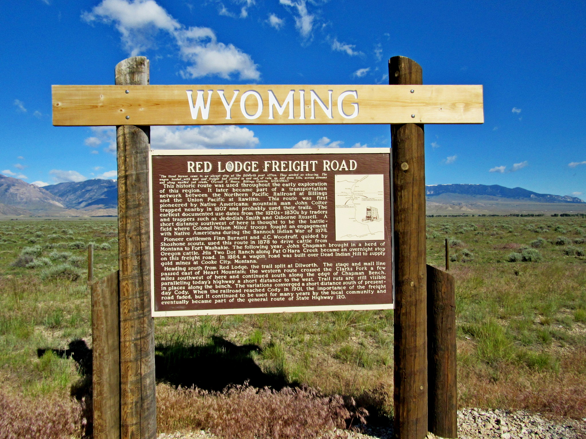
RED LODGE FREIGHT ROAD
The tired horses came to an abrupt stop at the Dilworth post office. They needed no whoa-ing. The wagon loaded with mail and freight had jostled in and out of ruts, up and down hills, across streams and along washed out roads: (Ferrell E. Henry. Billings Gazette, 6/28/1964)
This historic route was used throughout the early exploration of this region. It later became part of a transportation network between the Northern Pacific Railroad at Billings and the Union Pacific at Rawlins. This route was first pioneered by Native Americans: mountain man John Colter trapped nearby in 1807 and probably used their trails. The earliest documented use dates from the 1820s-1830s by traders and trappers such as Jedediah Smith and Osborne Russell. A short distance southwest of here is thought to be the battle-field where Colonel Nelson Miles' troops fought an engagement with Native Americans during the Bannock Indian War of 1878. Pioneer cattlemen Finn Burnett and J.C. Woodruff, guided by Shoshone scouts, used this route in 1878 to drive cattle from Montana to Fort Washakie. The following year, John Chapman brought in a herd of Oregon cattle. His Two Dot Ranch along Pat O'Hara Creek became an overnight stop on this freight road. In 1884, a wagon road was built over Dead Indian Hill to supply gold mines at Cooke City, Montana.
Heading south from Red Lodge, the trail split at Dilworth. The stage and mail line passed east of Heart Mountain; the western route crossed the Clarks Fork a few miles southwest of here and continued south along the edge of Chapman Bench. paralleling today's highway a short distance to the west. Trail ruts are still visible in places along the bench. The variations converged a short distance south of present-day Cody. When the railroad reached Cody in 1901, the importance of the freight road faded, but it continued to be used for many years by the local community and eventually became part of the general route of State Highway 120.
From the Wyoming Historical Highway Marker
 The History of the Wyoming Historical Highway Markers
Wyoming boasts one of the oldest monuments and markers program in the nation. At a time when few thought to mark history, interested and concerned residents of Wyoming realized the need to commemorate the past. These people placed monuments and markers that served to preserve a piece of the state’s heritage.
While the creation of the Wyoming Historical Landmarks Commission formally established a markers program in 1927, marking historic points actually began more than fifty years earlier. In 1875, the Union Pacific Railroad Company erected the Ames Monument, a 60-foot stone monument located at the original summit of the transcontinental railroad. The monument memorializes Oakes and Oliver Ames, brothers from Massachusetts, whose wealth and influence played an important role in the construction of the Union Pacific line through Wyoming.
The Union Pacific may have been the first to place a marker in Wyoming, but it was Ezra Meeker, an Oregon Trail veteran, who built support for marking important pieces of that great westward highway. Ezra Meeker was born in Huntsville, Ohio in 1830 and traveled over the Oregon Trail in 1852 with his wife. Meeker felt that the Oregon Trail was a “symbol of the heroism, the patriotism, the vision, and the sacrifices of the pioneers who had won the West for America.”
Twenty-two monuments and markers existed along the Trail when Meeker began a campaign to mark points in March 1906. By 1908, Meeker had succeeded in either directly or indirectly erecting 150 monuments. Inspired by Meeker’s actions, the Oregon Trail Memorial Association formed. Meeker served as the Association’s first president and helped to promote the Memorial Coin Bill. This bill authorized the creation and sale of Oregon Trail Memorial Fifty-Cent Pieces. The proceeds went to funding new signs. When Meeker died in 1928, the Association carried on his passion and vision for marking sites along the Trail.
The Daughters of the American Revolution (DAR) began marking historic places in 1908 and is responsible for many of the markers seen today.