In support of the construction of the
Grand Coulee Dam, the town of Coulee Dam was established to house the workers and service providers required, and later those who would operate the dam. This, the portion of the town in Okanogan County, on the northeast side of the Columbia River, came to be known as Mason City. It seems today to again be known as Coulee Dam, most of the portion across the river now known as Grand Coulee, with the town of Electric City further west.
This little park, originally named Mead Park, was renamed Mason City Memorial Park at an unknown time, possibly during the visit of Harry Truman in 1950. In the northwest corner of the park is
Presidential Plaza, a small fieldstone based area with three small plaques mounted on irregularly shaped granite stones, commemorating the visits of two presidents: that of Franklin Delano Roosevelt on October 2, 1937 and Harry S. Truman on May 11, 1950. Roosevelt addressed a crowd of 10,000 here, while Truman unveiled a plaque dedicating the lake behind Grand Coulee Dam as Franklin D. Roosevelt Lake.
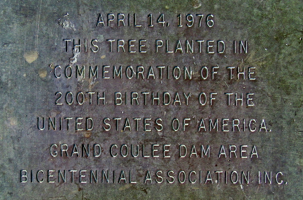
Front and centre in the park, just west of the visitor centre, is a Bicentennial Tree, planted on April 14, 1976. A healthy spruce, the tree has reached 20 feet in height and is soon to surpass 30 feet. The tree was planted by the Grand Coulee Dam Area Bicentennial Association. On a low concrete plinth in front of the tree, by the sidewalk, is mounted the following bronze plaque.
Coulee
Dam History
Coulee Dam is a town in Douglas, Grant, and Okanogan counties in the State of Washington. The Douglas County portion of Coulee Dam is part of the Wenatchee-East Wenatchee Metropolitan Statistical Area. The Okanogan County portion lies within the Colville Indian Reservation, and forms the southern limit of the Okanogan Highlands. The population was 1098 as of the 2010.
Coulee Dam was founded by the U.S Bureau of Reclamation in 1933, to serve as headquarters for construction of the Grand Coulee dam. The Okanogan County portion was known as Mason City, location of the head contractor. The Portions in Douglas and Grant Counties was known as Engineers Town and was government owned. In 1942 with the end of the contract in sight, CBI transferred control of Mason City to the Municipal Division of the Columbia Basin Project. In 1948 Mason City was incorporated in Coulee Dam. Government began the process of selling the town to the public in 1957, finishing in 1959.
It is the headquarters of Lake Roosevelt National Recreation Area, and home of one of the world's largest man-made piles of sand, a 12,000,000-cubic-yard (9,200,000 m3), 230-foot (70 m)-high hill remaining from dam construction.
From the Town of Coulee Dam