Background and History for Waytour
A thorough treatise on the background and reasons for the August 21, 1863 Raid would take my entire 15000 character limit for the waymark and then some. The "Cliff Notes" version - Lawrence was the hotbed for Jayhawking Raids into Missouri, including the sacking and burning of Osceola in 1861, among other towns. Jim Lane, the U.S. Senator from Kansas and resident of Lawrence, was a major instigator of these raids. The ultimate touchpoint for the Lawrence Raid was a collapse of a women's jail in Kansas City where several of the female relatives of some of the raiders were killed - including Quantrill and "Bloody" Bill Anderson. I encourage reading any of the many books that discuss the territorial "Bleeding Kansas" as well as the Lawrence Raid in particular for a fuller background.
Re-Ride with the Devil Waytour
This waytour will be several miles and will need to be completed by car. There will be opportunities to walk the middle section in downtown.
Please be vigilant driving in Lawrence, especially downtown, it can get pretty busy on weekends. Also, Massachusetts Street is a shopping haven - pedestrians do not always cross the street where they are supposed. Parking will be at a premium on weekends in downtown Lawrence, and is by meter. There is free parking on New Hampshire or Vermont.
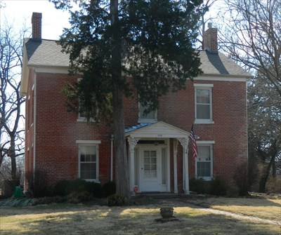
Robert Miller Home
Stop One: Robert Miller Home
The Robert Miller Home waymark -
WM13XC9
Coordinates - N 38° 56.983 W 095° 13.291
Parking Coordinates - N 38° 56.990 W 095° 13.325
Address - 1111 East 19th Street
Directions - Driving west on on 23rd Street, Turn right on Haskell Avenue. Turn right on 19th Street. No parking on 19th- park in the access road to the strip mall. Please be respectful - although the Robert Miller Home is on the National Register, it is a private residence.
After riding the better part of two days from their starting point in Johnson County, Missouri; crossing into Kansas at Spring Hill through Gardner and onto Lawrence; the first actual stop in Lawrence was at this Robert Miller Home just before dawn on the 21st. The Millers were from South Carolina, but held strong anti-slavery views. The raiders did not burn or kill anyone here - the first victim of the raid was Reverend S. S. Snyder. He was killed while milking a cow in the barn at his residence, which was located somewhere in the park to the west. Reverend Snyder was the chaplain of the 2nd Kansas Colored Infantry.
This house has a total of five waymarks - the posted WM13XC9; and WM13XCC, WM13XCE, WM13XCF, WM13XCH.
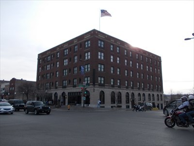
Eldridge Hotel
Stop Two: Eldridge Hotel
The Eldridge Hotel waymark -
WM6PNH
Coordinates - N 38° 58.265 W 095° 14.171
Nearest Street Parking Coordinates -N 38° 58.260 W 095° 14.161 (metered)
Address - 701 Massachusetts Street
Directions - Turn left onto 19th Street (west) 3/4ths of a mile to Massachusetts Street. Turn Right (north) approximately 1.5 miles to 7th and Massachusetts Street. The Eldridge is on the Southwest corner. Downtown Lawrence can be a challenge to park, especially on weekends, however, it is a good easy walking town.
The original Hotel built on this site was the Free-State Hotel in 1855. It was intended as a temporary place of lodging until more permanent lodging could be built in the fledgling town. This first Hotel was burnt to the ground by pro-Slavery Sheriff Sam Jones in 1856 during the "Bleeding Kansas" Territorial Era. The Hotel was rebuilt taller and grander by Colonel Shalor Eldridge.
The Hotel was again a major target of Quantrill when he attacked Lawrence in the early hours of August 21, 1863. After leaving the Millers and south Lawrence, Quantrill sent some men up to the top of Mount Oread - the large hill overlooking the town and now the home of the University of Kansas - to act as lookouts for Union troops. He then sent the main force through the town to capture the Free-State Hotel, now the Eldridge, as it was the largest building in Lawrence. Negotiations for the surrender of the guests of the Hotel were made and none were harmed. The Hotel, however, was destroyed again, once the guests were removed.. Once this supposed strongpoint was eliminated without much trouble, the real business of the Raid could take place. Groups of raiders fanned out throughout the town and began killing men and boys, ransacking businesses and homes, and burning most of Lawrence.
This Hotel has a total of nine waymarks - the posted WM6PNH, and WM13XCR, WMYGVB, WMK30P, WM6PNM, WM6PDB, WMGHJE, WMGJYP, WMGTF2.
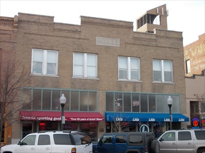
House Building
Stop Three: House Building
The House Building waymark -
WM10J15
Coordinates - N 38° 58.207 W 095° 14.164
Parking Coordinates -Leave car parked at Eldridge Hotel location.
Address - 729-731 Massachusetts
Directions - Walk south 1 block from the Eldridge Hotel - building is on left.
Built in 1858 and remodeled in 1921, the House Building is one of four buildings along Massachusetts Street to survive the fires. Unconfirmed rumors swirl after the Raid that House may have been a Quantrill sympathizer or may just have been friendly to him during his Territorial stay in Lawrence.
This building has a total of two waymarks - the posted WMGJK2 and WMGJKA.
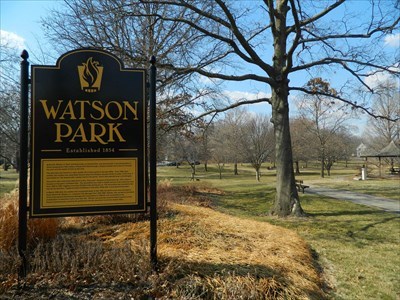
Watkins Park
Stop Four: Watson Park
The Watson Park waymark -
WM13XF2
Coordinates - N 38° 58.285 W 095° 14.310
Parking Coordinates - N 38° 58.278 W 095° 14.309
Address - Northwest corner of 7th and Kentucky.
Directions - Turn Left (west) on 7th Street and proceed two blocks to Kentucky. The waymarks are in the north section of the park.
This area is much different than on the morning of August 21, 1863. This was a wooded deep ravine with cornfields on either side. This area was also where many people - men, including Jim Lane, reportedly in his nightshirt, women and children - sought refuge from Quantrill's men. According to some reports, there were just enough potshots of gunfire coming out of the area to convince the raiders to stay clear of the area. The people who managed to get into this area survived the Raid. After the war, a culvert was put into the ravine for drainage and then filled. The area was then turned into a park. It is now much more peaceful than it was in August of 1863.
This building has a total of 9 waymarks - the posted WM13XF2; and WM13XG7, WM13XGD, WM13XGG, WM13XHV, WM13XJ0, WM13XJ3, WM13XJP, WM13XJY.
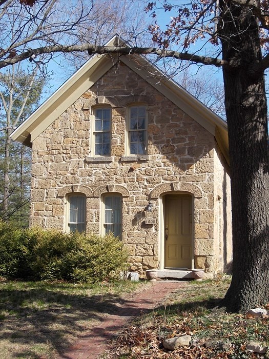
Bell House
Stop Five: Bell House
The Bell House waymark -
WMGEQA
Coordinates - N 38° 57.911 W 095° 14.426
Parking Coordinates -
Park on street - please note that this is a private residence.
Address - 1008 Ohio
Directions - Drive West on 7th Street 3 blocks to Ohio. Turn left South 3 blocks until you just cross 10th Street. The Bell House is on the southeast corner of 10th and Ohio.
"One of the oldest surviving residential buildings in Lawrence is the George and Annie Bell House at 1008 Ohio SAtreet. The builder, George Bell, was killed during Quantrill's infamous raid in 1863, and since that time the house has been considered significant by the community.
According to Cordley's history, the family was living in the house when Quantrill's raiders attacked the city of Lawrence on August 21, 1863. Bell had an important position as the clerk of Douglas County in 1863. He apparently acted bravely in the attempt to defend Lawrence from Quantrill's surprise attack. Cordley reported that Bell, when notified of the raid, told his wife, "They may kill me, but they cannot kill the principles I fight for. If they take Lawrence, they must do it over my dead body."
The citizens of Lawrence were unable to organize any effective resistance that day and Bell was killed. In fact, according to Cordley, after the raiders shot Bell, they came up the hill to threaten his wife saying, "We have killed your husband and we have come to burn his house." The house was set on fire, but the family saved it."
- National Register Application
This building has 1 waymark - the posted WMGEQA.
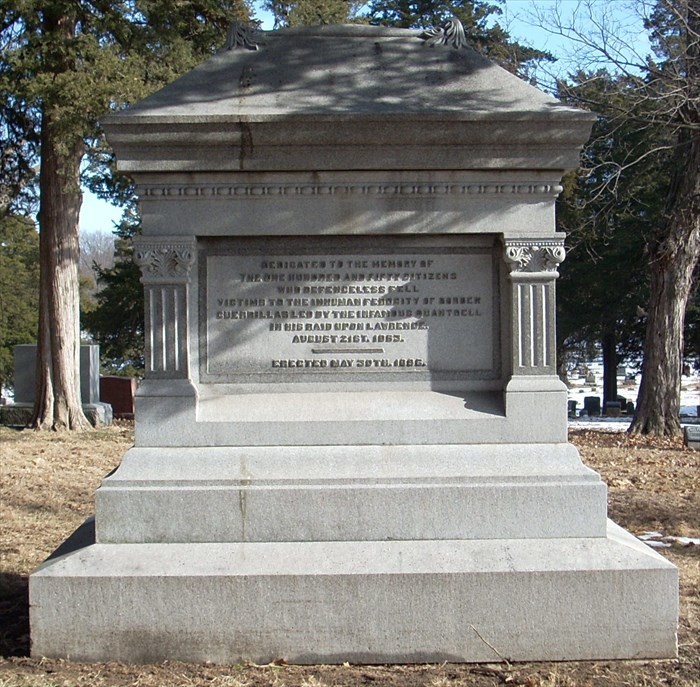
Quantrill Raid Victims Memorial
Stop Six: Quantrill Raid Victims Memorial
The Quantrill Raid Victims Memorial waymark -
WM2Y6A
Coordinates - N 38° 57.479 W 095° 12.721
Parking Coordinates -N 38° 57.480 W 095° 12.726
Address - Section 1, Oak Hill Cemetery, 1605 Oak Hill Drive
Directions - Drive South on Ohio 3 blocks to 13th Street.
Turn Left (East) on 13th. Go straight on 13th 1.1 miles, crossing Massachusetts to Oak Hill Avenue. Oak Hill Avenue will veer to the right (Southeast). This road will end at Oak Hill Cemetery. To get back to the starting point, exit the cemetery and make a Left (South) on Elmwood. Go one block and Turn Right on 15th Street (west). 7 blocks and the next major street is Haskell.
Turn Left (south) to 23rd Street to leave Lawrence.
"Following the devastation of Quantrill’s Raid in 1863, Lawrence survivors searched for ways to memorialize those killed in the attack. In 1864, the mayor urged the city to build a new cemetery since most raid victims were buried in Pioneer Cemetery which was far from town and difficult to maintain. A local newspaper editor helped gain public support for the project when he wrote that raid victims buried at Pioneer Cemetery were forgotten and their graves left unmarked.
Early in 1865, the city purchased land for a new cemetery. Instead of a simple, open cemetery, Lawrence’s city commissioners selected a rural cemetery design, with rolling hills, trees, and curving carriage paths which was the popular trend at the time. The new cemetery created a park-like space for the public. Oak Hill Cemetery soon became an important place to commemorate that terrible day in August 1863. For many years, citizens sponsored elaborate Decoration Day observances at Oak Hill, and by 1895, a local committee had raised funds to erect a large monument to honor the raid victims. The city continued to improve the cemetery through the late 1890’s by bringing city water to the site, constructing a receiving vault, and building a sidewalk from the downtown area.
There are so many individuals buried in Oak Hill who were influential during territorial days and the state's formation that William Allen White once called the cemetery, "The Kansas Arlington."
- Freedom's Frontier Website
This Memorial has 2 waymark - the posted WM2Y6A and WM12CCN.
Waytour Statistics & Miscellany
This waytour covers a total 4.75 miles between Stops one and six.
There are a total of 27 waymarks available in 19 different categories just with the stops. Google Maps of the individual stops are stored in the Picture Gallery of this Waytour.
A link to an additional tour I created that has the burial locations of Victims of the Raid, as well as Civil War Figures and Territorial Figures in Oak Hill Cemetery.
- Oak Hill Cemetery Tour
Finally, links to website sources to the Raid -
- Civil War on the Western Border Website
- Kansas State Historical Society Website
Of course, no in depth analysis of a Civil War subject is complete without a link to the Civil War Muse - there is a definite complete Raid Tour starting all of the way back in Missouri.
- Civil War Muse Website