|
 Entering Indian Territory OK
N 36° 59.800 W 094° 44.445
15S E 345101 N 4095919
Entering Indian Territory Oklahoma
Waymark Code: WM3A0G
Location: Oklahoma, United States
Date Posted: 03/02/2008
Views: 93
ENTERING INDIAN TERRITORY
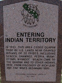
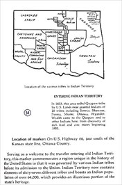
The above information is from the book, Mark of Heritage, by Muriel H. Wright, courtesy of Oklahoma Historical Society.
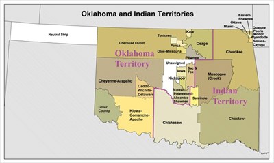
WIKI MAP
Photos by: GEO*Trailblazer 1
Type of Nation Within: Native American Indian Reservation (USA)

Tribe or Band: Quapaw and 20 others including Seneca,Shawnee,Peoria,Miami,Ottawa,Wyandot and others
Address of Main Entrance to area:
Hwy 69 Military Avenue
Historic Rt 66 just north
Quapaw, OK USA
Land Area - Specify Acres or Miles: Most of Oklahoma
Population: 64,000
Date when area was established or set aside: 01/01/1833
Open or Closed to Public: Open To Public
Website for further information: [Web Link]
Coordinates of site within area to visit: Not Listed
|
Visit Instructions:
Only one waymark per area (reservation) will be accepted, although you may log visits anywhere within the reservation because they oftentimes cover a large area. To log a visit to the waymark, please provide a photo of signage recognizing the area and a photo from within the area.
|