
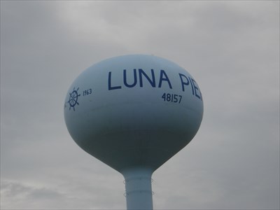
Luna Pier Water Tower - Luna Pier, MI
N 41° 49.211 W 083° 25.917
17T E 298018 N 4632670
This water tower is located at Harold Drive in Luna Pier.
Waymark Code: WM9MHM
Location: Michigan, United States
Date Posted: 09/04/2010
Views: 6
Luna Pier 48157, inc 1963
From: Wikipedia
Luna Pier
Luna Pier is a small city in Monroe County of the U.S. state of Michigan. It is located 6 miles from the Ohio border along the coast of Lake Erie. It was established in the early 1900s and incorporated as a city in 1963. It functioned primarily as a resort for people living in the greater Toledo, Ohio and Metro Detroit area. As of the 2000 census, the city population was 1,483.
Its most prominent feature is a large crescent-shaped pier made of concrete, approximately 800 ft long and reaching around 200 feet out into Lake Erie. The pier is flanked by sandy beaches and man-made rock and concrete embankments. On most days, the Davis-Besse nuclear power plant in Port Clinton can be seen from the pier. Also visible, are the Toledo Harbor Light and shipping channel.
Luna Pier, now established with mainly year round residents, attracts tourists interested in fishing, the public beach, bike trails, public boat ramp, marinas, ball fields, lake front scenery and the small-town atmosphere. The city is served by Mason Consolidated Schools.