
LEGACY - The Cascade Range of Oregon
Posted by:  Volcanoguy
N 44° 03.641 W 121° 17.001
10T E 637491 N 4880045
2006 sign which was replaced in 2016.
Waymark Code: WMABK
Location: Oregon, United States
Date Posted: 04/12/2006
Views: 61
This sign was located on western edge of summit observation area.
Marker Name: The Cascade Range of Oregon
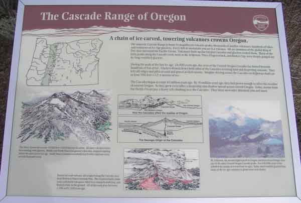
Marker Text: A chain of ice-carved, towering volcanoes crowns Oregon.
The majestic Cascade Range is home to magnificent volcanic peaks, thousands of smaller volcanoes, hundreds of lakes and remnants of Ice Age glaciers. Every hill or mountain you see is a volcano. All are members of the global Ring of Fire that surround the Pacific Ocean. Volcanoes built up the Oregon Cascades and glaciers erode them. Many of the lofty peaks along the Cascade crest, such as Mt. Jefferson, Three-Fingered Jack, and Broken Top were deeply gouged out by long-vanished glaciers
During the peak of the last ice age, 18,000 years ago, the crest of the Central Oregon Cascades lay buried beneath hundreds of feet of ice. Glaciers flowed down both sides of the Cascades scouring land and deepening canyons. They left tall ridges and piles of sand and gravel at their snouts. Imagine driving across the Cascades on highways built on at least 500 feet (152.4 meters) of ice.
The Cascades began to erupt 40 million years ago. By 20 million years ago, they had grown enough to affect the weather of eastern Oregon. As the grew even taller, a deepening rain shadow spread across eastern Oregon. Today, storms from the Pacific Ocean pay a heavy toll climbing over the Cascades. They must surrender abundant rain and snow.
The Three Sisters rise to over 10,000 feet (3,048 meters) elevation. All three volcanoes have been dueling with glaciers. Middle and North Sister lost ground when they stopped erupting before the most recent ice age. South Sister continues to rebuild itself with eruptions every several thousand years.
Barren lava and volcanic ash erupted along the Cascade crest from McKenzie Pass to Santiam Pass. The eruptions built cinder cones and shield volcanoes, filled river channels with lava, and blasted a hole in the ground. All of this took place between 1,500 and 4,500 years ago.
Mt. Jefferson, the second highest peak in Oregon, has been around longer than any of the other Central Oregon Cascade peaks. For 600,000 years it has rebuffed the attacks of at least four ice ages. Today, much smaller glaciers than those of the ice ages continue to grind away at its flanks.
Visit Instructions:
Include your thoughts and observations pertaining to this location and your visit. Provide any additional history that you are aware of that pertains to this location. If the marker commemorates a historic building tell us what it is used for now or share with us the circumstances of an earlier visit to bring this locations history to life.
Please upload a favorite photograph you took of the waymark. Although visiting this waymark in person is the only thing required of you to receive credit for your visit, taking the time to add this information is greatly appreciated.
Be creative.