Marker Text:
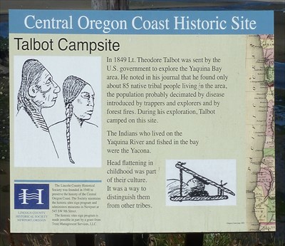
Central Oregon Coast Historic Site
Talbot Campsite
In 1849 Lt. Theodore Talbot was sent by the
U.S. government to explore the Yaquina Bay
area. He noted in his journal that he found only
about 85 native tribal people living in the area,
the population probably decimated by disease
introduced by trappers and explorers and by
forest fires. During his exploration, Talbot
camped on this site.
The Indians who lived on the
Yaquina River and fished in the bay
were the Yacona.
Head flattening in
childhood was part
of their culture.
It was a way to
distinguish them
from other tribes.
===================
There is also a diagram of two Indians with flattened heads and
another diagram of a child sleeping with a flattening device.
On the lower left is the following information:
Lincoln County
Historical Society
Newport, Oregon
The Lincoln County Historical
Society was founded in 1948 to
preserve the history of the Central
Oregon Coast. The Society maintains
the historic sites sign program and
administers museums in Newport at
545 SW 9th Street
The historic sites sign program is
made possible in part by a grant from
Trust Management Services, LLC.
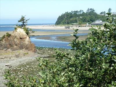
Schooner Creek at Siletz Bay
Talbot Campsite
Here is a brief account of Lt. Talbot's expedition which states that he camped here on August 26, 1949.
U.S. ARMY- Lt. Theodore Talbot was instructed by General Persifor F. Smith at Ft. Vancouver to examine the coast of Oregon, especially the Alsea River area. Talbot, with a detachment of a sergeant and nine men, left Ft. Vancouver, went to Oregon City and hired Joaquin Umphraville (French trapper) to act as guide and interpreter. They left Oregon City on the 20th, traveling up the eastern side of the Willamette to Champoeg, crossing the Willamette at a ferry three miles above then up the Willamette Valley. The party reached Kings Valley (in 1856 the site of Ft. Hoskins) on the 24th. The next day they turned west following a Klickitat Indian trail which crossed Marys River several times. On the 26th, they camped on a fork of the Siletz River. The party met Governor Lane and two other gentlemen on the lower river. Lane informed them that one year before a party of white men discovered coal in the vicinity. Lane was there to examine the area. On the 29th, they parted company with Gov. Lane and went on to Yaquina Bay. The next day, Talbot hired a canoe with five Indian paddlers to examine the mouth of Yaquina Bay and on to Alsea Bay. On September 7th the party reached Devils Lake, then eastward up a trail (along Salmon River) used by settlers in the Willamette Valley to drive cattle to the coast and on to Astoria. The next day they crossed the summit, then down the Yamhill River to the Willamette River and on to Oregon City on the 13th. Two days later he was back at Ft. Vancouver.
From an article in
Roots/Ancestry.com by Ann Talbot Brandon Womack and Farris W. Womack.
Talbot writes in his journal of his arrival at this campsite:
Reach Siletz
August 26 Our road today, like that of yesterday, was full of steep ascents and yet more precipitous declivities, and much obstructed by fallen trees and thick brush. We passed through one tract of burnt forest several miles in. extent, where the little trail which we followed, indifferent at the best, was often completely broken. up, and we were compelled to have recourse to our axes to make a way through the heaps of charred logs. We descended, after a toilsome day's journey into a grassy valley, about half a mile in length, watered by a fork of the Celeetz (13) river, in which we encamped, having made nine miles.
Another journal entry on August 29th gives this account of his meeting with the Yaconas, making no mention of the head flattening:
Riding a mile down the shore of the bay with my interpreter, we came to a small Indian village; whose occupants received us very kindly. They call themselves Yaconas. The Indians residing on the Celeetz, Yacona and Alcea bays, all speak the same language and belong to the same nation; but each bay has its respective chief. There are about 80 of them, all told, living on this bay. They are generally well formed. intelligent, and of healthy appearance, apparently not being subject to those eruptive diseases of the skin which prevail so extensively among some of the tribes in the Columbia. Most of them talk the Chinook jargon, a singular medley of corrupted English, French and Chinook words, spoken by the different Indian tribes of this coast in their intercourse with each other and the whites, somewhat as the French language is used among the polished nations of Europe. The Yaconas subsist principally on fish. clams, crabs and roots, occasionally hunting the elk in the neighboring mountains. They do not possess any horses, and have had but. little intercourse with the whites; neither the chief nor any of his people had ever visited the Willamette valley.
Entries Compiled and
Notes on Contents by
LESLIE L. HASKIN
Newport Oregon
Reprinted from files of Newport News
Oregon State University Library
Visit Instructions:
Include your thoughts and observations pertaining to this location and your visit. Provide any additional history that you are aware of that pertains to this location. If the marker commemorates a historic building tell us what it is used for now or share with us the circumstances of an earlier visit to bring this locations history to life.
Please upload a favorite photograph you took of the waymark. Although visiting this waymark in person is the only thing required of you to receive credit for your visit, taking the time to add this information is greatly appreciated.
Be creative.