
Powerful Waves Mold this Landscape
Posted by:  silverquill
N 44° 44.830 W 124° 03.894
10T E 415701 N 4955416
These two signs detail the geologic history of Devil's Punch bowl at Otter Rock.
Waymark Code: WMD161
Location: Oregon, United States
Date Posted: 11/05/2011
Views: 8
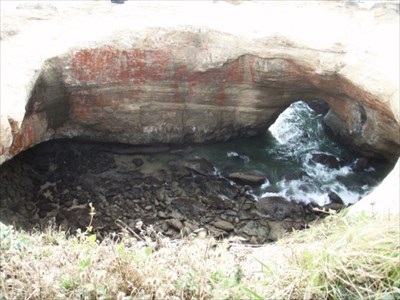
The scenic Coast Highway, U.S. 101, passes inland east of this location, but a short trip out to Devil's Punch Bowl is well worth the time.
There is a scenic viewpoint here with vistas of the coastal cliffs and this most unusual formation when the roofs of two caves collapsed forming a bowl. A natural arch at the bottom allows the water to enter. At low tide this formation is visible, but at high tide this is a roiling cauldron of wave action. And, it is almost always windy here.
Plan on having a meal at Mo's location here, famed for clam chowder, the freshest sea food from the wharves of nearby Newport and Depoe Bay, and the hospitality of the Oregon coast.
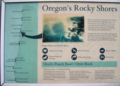
Oregon's Rocky Shores
Below you is the spectacular Devil's Punch
Bowl which was formed when the roof
over two sea caves collapsed. You can
watch the ocean waves crash through
openings in the sandstone, continually
sculpting this unusual formation.
At high tide, the waves churn through the
openings below the water's surface, filling
the cavern and creating the formation
appropriately named Devil's Punch Bowl.
Enjoy these activities here:
Tidepool Viewing
Bird Watching
Shore Angling
Marine Mammal Viewing
Whale Watching
Picnicking
Devil's Punch Bowl/Otter Rock
This site is part of a Marine Garden
To your right is the southern tip of a
Marine Garden that extends one mile
north to the Otter Crest State Scenic
Viewpoint. This large area offers many
opportunities to enjoy and learn about
marine ecosystems.
Because this area is designated as a
Marine Garden, no collecting of clams
mussels, or any other marine
invertebrates is allowed, except for
fishermen, who may collect single
mussels for bait.
Please enjoy the tidepool creatures
where they live and be careful where
you step. To learn more about this
productive and fascinating marine
ecosystem, please read the signs to your
right overlooking the rich habitat.
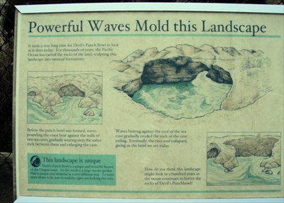
Powerful Waves Molded this Landscape
It took a very long time for Devil's Punch Bowl to look
as it does today. For thousands of years, the Pacific
Ocean has carved the rocks of the land, sculpting this
landscape into unusual formations.
Before the punch bowl was formed, waves
pounding the coast beat against the walls of
two sea caves, gradually wearing away the softer
rock between them and enlarging the cave.
Waves beating against the roof of the sea
cave gradually eroded the rock of the cave
ceiling. Eventually, the cave roof collapsed,
giving us the bowl we see today.
How do you think this landscape
might look in a hundred years as
the ocean continues to batter the
rocks of Devil's Punchbowl?
This landscape is unique
Devil's Punch Bowl is a unique and beautiful feature
of the Oregon coast. To the north is a large marine garden
that it unique and beautiful in a very different way. To learn
more about it, be sure to read the signs overlooking this area.
Visit Instructions:
Include your thoughts and observations pertaining to this location and your visit. Provide any additional history that you are aware of that pertains to this location. If the marker commemorates a historic building tell us what it is used for now or share with us the circumstances of an earlier visit to bring this locations history to life.
Please upload a favorite photograph you took of the waymark. Although visiting this waymark in person is the only thing required of you to receive credit for your visit, taking the time to add this information is greatly appreciated.
Be creative.