
Olson Observation Tower - Monongahela National Forest - Black Fork, WV
N 39° 06.414 W 079° 36.211
17S E 620744 N 4329568
Olson Tower is a 133-step climb to the observation deck. It is located in the Monongahela National Forest in Tucker County, West Virginia.
Waymark Code: WMER59
Location: West Virginia, United States
Date Posted: 06/30/2012
Views: 7
Olson Observation Tower - Monongahela National Forest - Black Fork, WV
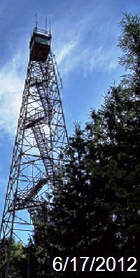
The Olson Observation Tower, located on top of Backbone Mountain in Tucker County, West Virginia in the midst of the Monongahela National Forest, is located at an elevation of 3,736 Feet above sea level. This tower, constructed in 1963, is the second tower constructed on this site after West Virginia's first fire tower was constructed in 1922. The current tower, when constructed, was named in honor of Ernst B. Olson, a forest fire fighter, with 28 years of experience.
From the deck at the top of the tower, you can see nearby locales, such as, Parsons, Cannan Valley, Blackwater Canyon, the rest of Backbone Mountain, and the Otter Creek Wilderness.
The tower is accessible to the top via 133 steps and is accessible via vehicle from April 1 - December 13 annually