This historical marker is one of several in a series found in downtown Salem and in West Salem's Edgewater District. This marker is located at the east end of the parking lot by the old West Salem City Hall. The marker text reads:
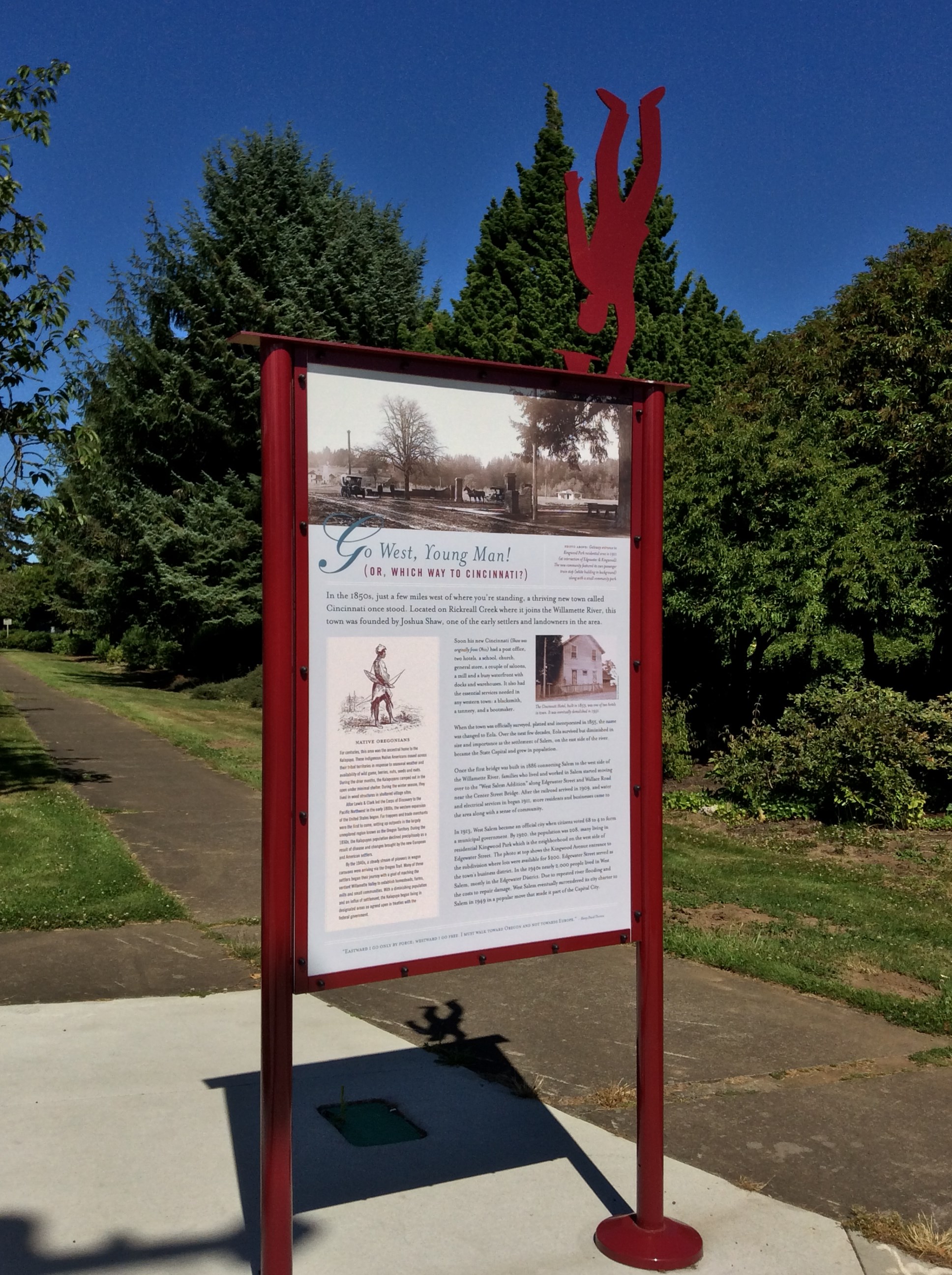
Go West, Young Man!
(OR, WHICH WAY TO CINCINNATI?)
In the 1850's, just a few miles west of where you're standing, a thriving new town called Cincinnati once stood. Located on Rickreall Creek where it joins the Willamette River, this town was founded by Joshua Shaw, one of the early settlers and landowners in the area.
Soon his new Cincinnati (Shaw was originally from Ohio) had a post office, two hotels, a school, church, general store, a couple of saloons, a mill and a busy waterfront with docks and warehouses. It also had the essential services needed in any western town: a blacksmith, a tannery, and a bootmaker.
When the town was officially surveyed, platted and incorporated in 1855, the name was changed to Eola. Over the next few decades, Eola survived but diminshed in size and importance as the settlement of Salem, on the east side of the river, became the State Capitol and grew in population.
Once the first bridge was built in 1886 connecting Salem to the west side of the Willamette River, families who lived and worked in Salem started moving over to the "West Salem Addition" along Edgewater Street and Wallace Road near the Center Street Bridge. After the railroad arrived in 1909, and water and electrical services began in 1911, more residents and businesses came to the area along with a sense of community.
In 1913, West Salem became an official city when citizens voted 68 to 4 to form a municipal government. By 1920, the population was 208, many living in residential Kingwood Park which is the neighborhood on the west side of Edgewater Street. The photo at top shows the Kingwood Avenue entrance to the subdivision where lots were available from $200. Edgewater Street served as the town's business district. In the 1940s nearly 2,000 people lived in West Salem, mostly in the Edgewater District. Due to repeated river flooding and the costs to repair damage, West Salem eventually surrendered its city charter to Salem in 1949 in a popular move that made it part of the Capital City.
Photo Captions:
PHOTO ABOVE: Gateway entrance to Kingswood Park residential area in 1911 (at intersection of Edgewater & Kingwood). The new community featured its own passenger train stop (white building in background) along with a small community park.
The Cincinnati Hotel, built in 1853, was one of two hotels in town. It was eventually demolished in 1951.
NATIVE OREGONIANSFor centuries, this area was the ancestral home to the Kalapuya. These indigenous Native Americans moved across their tribal territories in response to seasonal weather and availability of wild game, berries, nuts, seeds and roots. During the drier months, the Kalapuyans camped out in the open under minimal shelter. During the winter season, they lived in wood structures in sheltered village sites.
After Lewis & Clark led the Corps of Discovery to the Pacific Northwest in the early 1800s, the western expansion of the United States began. Fur trappers and trade merchants were the first to come, setting up outposts in the largely unexplored region known as the Oregon Territory. During the 1830s, the Kalapuyan population declined precipitously as a result of disease and changes brought by the new European and American settlers.
By the 1840s, a steady stream of pioneers in wagon caravans were arriving via the Oregon Trail. Many of these settlers began their journey with a goal of reaching the verdant Willamette Valley to establish homesteads, farms, mills and small communities. With a diminishing population and an influx of settlement, the Kalapuyan began living in designated areas as agreed upon in treaties with the federal government.
"EASTWARD I GO ONLY BY FORCE; WESTWARD I GO FREE. I MUST WALK TOWARD OREGON AND NOT TOWARDS EUROPE." -Henry David Thoreau
Click a photo to enlarge

On the backside of this marker is a  "You are Here" map, designed to orient pedestrians to Salem's nearby points of interest.
Visit Instructions:
Include your thoughts and observations pertaining to this location and your visit. Provide any additional history that you are aware of that pertains to this location. If the marker commemorates a historic building tell us what it is used for now or share with us the circumstances of an earlier visit to bring this locations history to life.
Please upload a favorite photograph you took of the waymark. Although visiting this waymark in person is the only thing required of you to receive credit for your visit, taking the time to add this information is greatly appreciated.
Be creative.